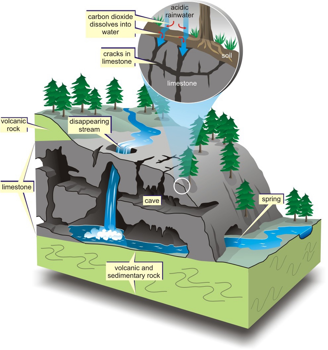
About 350-200 million years ago, the Earth went through drastic tectonic transformations, leading to the creation of limestone sediments that Vietnamese often refer to as "Bac Son limestone". The limestone rises out of the water and gradually grows over time into big and small islands of different shapes in the current Ha Long Bay and Cat Ba archipelago area. Limestone is also a very sensitive type of rock and easily subjected to the dissolving corrosive effects of carbonated rainwater.

Rainwater erodes the surface of limestone layers and cracks, creating a myriad of peculiar shapes and trenches. Lying among them is the type of rock known symbolically as "cat ear rocks", or “rugger rocks” as the common name.
Rainwater partly flows along countless existing rock cracks and widen the fissures. Over time, the fissures grow to become an underground void that will be called "caves" as a common. Fissures, small gaps, and caves are interconnected and form underground space.
This process of limestone erosion or "karstization" of water (including rain, underground, and surface water) formed uneven limestone terrain such as peaks, ranges with peculiar shapes. Between them are very diverse terrains such as funnels, valleys, deep wells, abysses, valleys, fields, plains ...
The term "Karst" - originates from the Balkan region. "Karst" is used to refer to the geological feature of the Karst region of Croatia, near the coast of the Adriatic Sea. In German, "Krast" refers to a form of rock.
The low latitude, especially humid tropical karst terrain often has a very thick forest vegetation cover, high biodiversity, and known as the "subtropical karst system". Such an environment contains a very special dual-ecosystem: the visible environment we can observe and the underground environment that is difficult to access.

In Vietnam, limestone (karst terrain) accounts for nearly 20% of the land area, is about 60,000 km2. Limestone is concentrated mostly in the North of Vietnam.
The Ha Long - Cat Ba region has undergone continual continental karstization for nearly 350-200 million years, creating a karst-top landscape with valleys stretching in the Northwest - Southeast direction. At the same time, there is a small number of small karst fields.
Hidden inside limestone clocks are caves of different sizes, shapes, and latitudes. The Halong - Catba area in the western edge of the Gulf of Tonkin has subsided, leaning on the South-Southeast direction. The limestone in Halong - Catba area is affected simultaneously by the dissolving activities due to rainwater on the surface and the corrosion of seawater.

The sea penetrated to the karst terrain of Halong-Catba area about 40,000 years ago, then receded and narrowed down the region. About 2000 years ago, the sea rose again, the bay continued to expand. Curently, the sea tends to rise again and form the area as we are familiar with.
The seawater erodes limestone and changes the formation drastically, leaving "jaws" very common at the base of islands in the bay. Many famous sites such as the Cock Fighting Islet in Ha Long Bay, or Pen Islet in Lan Ha bay have this very clear eroded base. In addition, the seawater even erodes and destroys ancient caves. The sea level fluctuated continuously for many periods up on the cliffs and those marks are still visible nowadays.
There are impressive stalactites and stalagmites in the Halong-Catba area, formed by rainwater erosion over time. Those are called "Rock bells" and their size can be up to several meters in length.

If we cut the stalactites, we can see concentric layered structures similarly found in tree trunks. That proves that those "Rock Bells" increased in size by accumulating layers. In some cases, the rock bells have a tubular structure and hollow in the middle. Stalagmites are similarly structured, formed by raindrops from the ceilling. When stalactites and stalagmites grow enough, they will connect and form stone pillars.